When Henry David Thoreau (1817-1862) traveled the Sudbury and Concord rivers, he encountered a landscape in transition. The river he observed was neither untouched wilderness nor the river residents know today. It was one moment in a landscape that had already undergone thousands of years of change from natural forces and human activity.
Thoreau recorded water levels, flowering dates, wildlife, ice, floods and the effects of dams in his journal, which comprised 47 volumes. His observations allowed him to consider the river, plants, animals, weather and human activity as connected parts of a living system — decades before scientists widely used the word “ecosystem.”
A river shaped before Thoreau
Successive tectonic collisions folded and faulted the rock that became Massachusetts. Glaciers scraped the bedrock, created sand and gravel deposits and glacial meltwaters created lakebeds that the Sudbury, Assabet and Concord rivers now flow through.
Two geologic features help mark the length of the meadowland reaches of the river. One is at the falls now occupied by the Saxonville Dam in Framingham. The other is the exposed granite bedrock ledge around the shallows at the Fordway in North Billerica, near the Pollard Street Bridge upriver from the Talbot Mills Dam.
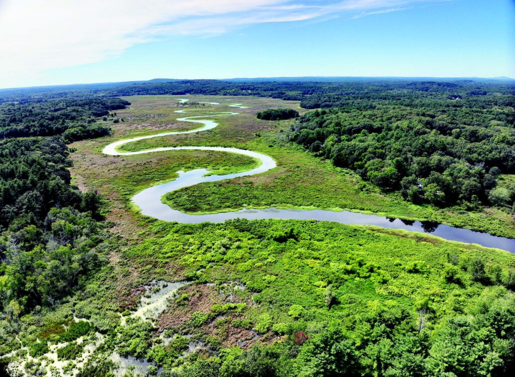
Between those two features the river moves slowly through a channel approximately 4 to 7 feet deep bordered by flood plains and broad wetlands and on what were glacial meltwater lakebeds. During floods, water spreads across those low-lying lands and then drains gradually back toward the main channel.
Long before Thoreau explored the river, Indigenous people lived and traveled throughout the watershed. Thoreau often used “Musketaquid,” an Indigenous name commonly translated as “grass-ground river,” when writing about the Concord River and its broad meadow landscape.
Archeological evidence shows that humans have lived in the Concord basin region going back as far as 12,000 years, continuing across the Paleoindian, Archaic and Woodland periods. Among the Eastern Algonquian-speaking Indigenous tribes present in this region were the Nipmuc, Pawtucket, Wampanoag, and Massachusett.
In a March 28, 1859, journal entry, Thoreau explained that plowing, melting snow, rain and freshets exposed artifacts. On that afternoon, he landed at two places and collected 12 objects he called arrowheads, now more generally described as projectile points. His journal entries confirm that looking for Indigenous artifacts on exposed island soils had become a regular part of his river observations.
As the postglacial climate warmed, the landscape changed from cold tundra and woodland forests of spruce and fir to those dominated by trees including oak, pine and hickory. People adapted their hunting, fishing and gathering practices to those changing conditions. Agriculture, including the cultivation of corn, beans and squash, became more important during the later Woodland period.
Thoreau reflected in “A Week on the Concord and Merrimack Rivers” on how industry was altering the natural landscape and disrupting long-standing ecological patterns: “Salmon, Shad, and Alewives were formerly abundant here, and taken in weirs by the Indians, who taught this method to the whites, by whom they were used as food and as manure, until the dam, and afterward the canal at Billerica, and the factories at Lowell, put an end to their migrations hitherward.”
The working river Thoreau knew
By Thoreau’s lifetime, generations of European settlers extensively altered the landscape by clearing New England forests for fields, pasture, buildings and fuel. Forests were reduced to their smallest extent in Massachusetts. They drained wetlands, built stone walls, roads, canals and erected dams to power gristmills, sawmills and later factories.
Mills and dams were changing how water and sediment moved downstream. Along the Sudbury and Concord rivers, the annual spring flood — known as the freshet — renewed the riverside meadows that the farmers depended upon. As the water receded, farmers could enter the meadows in late summer to cut hay. What today are called meadows and wetlands, in Thoreau’s time would have been called pasture and meadowland.
The timing and depth of flooding affected the outcome of the harvest. Water that remained too long could delay or destroy the hay crop. Dams that raised river levels became sources of conflict between mill owners and upstream farmers whose meadows stayed wet.
Thoreau observed those tensions as the region shifted from an agricultural economy toward an industrial one. His journals record not just plants and animals but also bridges, dams, mills, drainage and other human interventions in the river system. Through his own work as a surveyor of land and wood lots, Thoreau contributed to the transformation of the landscape.
As New England agriculture declined during the 19th century, forests began reclaiming abandoned fields. The heavily cleared landscape Thoreau knew gradually became more wooded, even as towns, roads and industries expanded. The regrowth did not recreate the same forest tree species mix that had existed before European settlement.
Measuring Thoreau’s river today
Modern measurements help explain the sluggish river that Thoreau described.
A 1996 National Park Service study reported a drop in river elevation of about two feet between Saxonville and the Route 3 bridge in Billerica. Over the approximately 24.6-mile reach, that amounts to an average decline of about one inch per mile.
Dams, bedrock controls, tributaries, wetlands and channel geometry affect water levels along different sections of the river so the river elevation drop varies. The two-foot figure should not be interpreted as a surveyed channel-bed gradient.
The U.S. Geological Survey operates a monitoring gauge on the Sudbury River at Saxonville, near the Danforth Street bridge. Farther downstream, it operates a gauge on the Concord River below River Meadow Brook in Lowell, near the area historically known as Wamesit Falls.
The gauges are separated by about 32 river miles. They provide long-running stage and discharge records of local conditions at those points of this nearly flat section of the river corridor.
The river’s low gradient helps explain why high water can spread widely across its floodplain and remain there. Modifications to dams, bridges, wetlands or drainage in one community can affect water levels, flood storage and the timing of flows beyond that one community.
Where the current slows, suspended material can settle in the channel, wetlands and floodplain. The locations and amounts of deposition depend on water velocity, tributary inputs, dams, channel shape and flood conditions.
From hay meadows to wildlife refuge
Land that farmers once valued for hay now forms part of one of the region’s most important wetland systems. In 1928, a hunter named Samuel Hoar purchased a piece of land along the Concord River and built dams and dikes to hold the water in the marshes, enhancing their value as waterfowl habitat. In 1944 he donated 250 acres of this land, according to the U.S. Fish and Wildlife Service, creating the Concord Unit of the Great Meadows National Wildlife Refuge.
In time, additional acres by more donors were added. The agency reports approximately 85% of the Great Meadows National Wildlife Refuge’s now more than 3,800 acres consists of freshwater wetlands extending along about 12 miles of the two rivers.
The purpose of those protected meadows has changed, but their hydrology remains central. Seasonal flooding creates habitat for waterfowl, fish, turtles, amphibians, aquatic plants and other wildlife. The wetlands also store the flood water, reduce its velocity and release it gradually.
Thoreau would still recognize some parts of his landscape. His observations continue to offer a baseline snapshot of a continuously evolving river ecosystem.
This work is supported by a grant from the River Stewardship Council which acts as the local partner to the National Park Service through which the protections of the federal Wild and Scenic Rivers Act is implemented.